- Compact style
- Indico style
- Indico style - inline minutes
- Indico style - numbered
- Indico style - numbered + minutes
- Indico Weeks View
Your profile timezone:
Help us make Indico better by taking this survey! Aidez-nous à améliorer Indico en répondant à ce sondage !

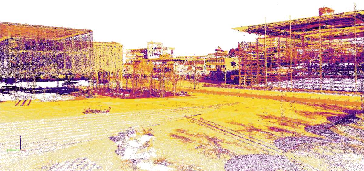
Daylight Simulation Pointcloud of Campus Hoenggerberg, Dr. Michael Walczak, Suzana Lepanovic, Prof. Hubert Klumpner. Chair of Architecture and Urban Design, ETHZ, 2022.
By 2050, up to six billion people are expected to live in urbanising areas. Accelerating growth and increasing densification raise questions for architects and engineers, especially those whose work connects inside and outside spaces in the development of one climate neutral system. Challenges include the design of public, open, and green spaces, the provision of outdoor comfort, and the need for daylight control, among many more. Consequently, the shaping of urban environments requires an integrated understanding of various fields, especially those that focus on solar radiation, energy production, and heat/cold islands to mitigate climate change. Our capacity to shape daylight in urban transformation processes will decide if we will achieve Carbon Neutrality.
Provision of daylight – essential for our health and well-being for living and working – in such densified cities, where inhabitants spend an increasing amount of time indoors, is becoming an imperative for urban design. Inclusive urban environments require high degrees of social-environmental sustainability to provide a high quality of life to all people.
To make cities and human settlements more inclusive, safe, resilient, and sustainable we propose sharing key principles and analysis methods for exploring science, technology and policy. How can urban design of comfortable ‘inside-out’ environments reduce energy use and associated climate change effects? What factors decide the layout of a city? What is the role of daylight in urban design? How does it affect people, their behaviour, and their health? Where do people choose to spend their time indoors and outdoors, taking into account their mobility patterns? What are the qualities and quantities of daylight they experience in buildings, as well as the environmental qualities and programs of public spaces? And, how can urban planning create opportunities for daylight access in cities, whether it’s inside or outside of buildings?
Daylight assessments have been established in performance-driven design, however with a strong focus on indoor environments. Connecting inside and outside into one environmental system is at the core of the “Inside – Out” Daylight in Sustainable Urban Design Conference.
Organizing Committee
Prof. Hubert Klumpner
Professor of Architecture and Urban Design
Dr. Michael Walczak
Klearjos Eduardo Papanicolaou
Prof. Dr. Arno Schlueter
Professor of Architecture and Building Systems
Dr. Lars O. Grobe (Velux Stiftung Daylight Fellow)
Selection Committee
Prof. Hubert Klumpner
Professor of Architecture and Urban Design, LUS
Dr. Michael Walczak
Klearjos Eduardo Papanicolaou
LUS Institute for Landscape and Urban Studies NSL Network City Landscape
Prof. Dr. Arno Schlueter
Professor of Architecture and Building Systems, ITA
Dr. Lars O. Grobe
Velux Stiftung Daylight Fellow
ITA Institute of Technology in Architecture
Judit Solt, Dipl.-Arch. ETH SIA
Chefredaktorin TEC21 - Schweizerische Bauzeitung
Dr. Chantal Basurto
Renewable Energy Institute, National Autonomous University of Mexico
Partners:


Supported by:

Posters addressing aspects of both tracks "inside daylight" and "insise - out daylight" will be displayed at the conference venue.
Coffee break with exhibition of posters and presentation of short movies resulting from an experimental daylight course at ETHZ, introduced by Klearjos E. Papanicolaou.
Brown-bag lunch with exhibition of posters and presentation of short movies resulting from an experimental daylight course at ETHZ.
This research seeks for indicators and methods of characterization, evaluation, certification and/or accreditation of integrative litgting for indoor workplaces. We carried out an online three-stage Delphi study to select descriptors and indicators of integrative lighting: (I) consensus of descriptors, (II) consensus of indicators, (III) weighting of descriptors and indicators. This paper presents the results of stages I and II, In stage I, we defined five dimensions of integrative lighting (i.e. Visual Performance, Visual Comfort, Sight, Control, Vitality) based on the Ergonomic Lighting Indicator (ELI) method. Based on a literature review, we proposed a set of descriptors, and then we invited lighting experts rated them in a five-point scale from "not important at all" to "very important". There was consensus when a descriptor was rated as "important" or "very important" by at least 75% of experts. Consented descriptors continued to stage II, where we classified them as (i) VISUAL/PHOTOMETRIC descriptors (i.e illuminance levels: luminance contrasts; occurrence and magnitude of physiological and discomfort glare; occupants' perception and opinions, daylighting, circadian lighting, complementary parameters of lighting, and lighting control and flexibility) or (ii) TEMPORAL/HUMAN FACTORS descriptors (i.e. age, preferences, task, and environment). In stage II, consensus required 50% of expert agreement.
Thirty-two experts participated in Stage I. For Visual Performance, four out of six descriptors exceeded the threshold. In Vista, two did not reach the threshold. All of the experts indicated the importance of flicker in Visual Comfort. For Vitality, the most important descriptor was stabilization of the circadian cycle. Finally in Control, only basic aspects of lighting control exceeded the threshold. Twenty-Three experts participated in Stage II. Regarding VISUAL/PHOTOMETRIC descriptors, there was a strong agreement in measuring at the specific plane of the visual task with a calibrated equipment to determine illuminance levels. In relation to user perceptions and opinions, there was consensus on using validated subjective instruments (i.e. questionnaires) and on the use of luminance meters for assessing both physiological and discomfort glare. In relation to TEMPORAL/HUMAN FACTORS, experts recommended measuring at specific time/s based on criteria under a dynamic lighting paradigm (i.e. repeated measurements). There was no consensus in recommending whether to perform lighting assessments at the current, the usual, or the worst lighting conditions. Finally, most experts recommended considering both the age and preferences of the occupants when assessing daylighting and illuminance levels, and only age when assessing disability glare. For the next stage, we plan to hold meetings with the experts who have participated in this work in order to learn their opinion regarding the analysis of the results presented in this paper.
The design strategy of architect Zlatko Ugljen is explored through the analysis of three buildings. All three selected objects are sacral and are located in the territory of B&H. Through universality in approach and connecting tradition with a global language, a design language was created. The relationship with daylight plays a key role, both in the creation of volumes and in the formation of the atmosphere within them. The approach to this kind of design and the use of zenithal light can be traced through history. One of the most significant predecessors is the Roman Pantheon, or even old caves which were our first hiding places and places where we found the first drawings, and where the first mythology is born and respect for the supernatural started.
The first object we are analyzing is the Šerafudin's White Mosque in Visoko (43.985186, 18.180146). The mosque was designed in 1969, in the context of the then social conditions of the socialist state of Yugoslavia. Through a modern approach, a unique solution is created which differs from existing typologies (primarily Ottoman type). The design inspiration is sought at the story related to the Prophet Muhammad's stay in the cave. The architect creates an artificial concrete cave, shaped like a quarter of a compartment, with five zenithal openings in the roof. These openings are associated with the five daily prayers in Islam and are connected to the position of the sun during the day.
The first monastery and church in Plehane were destroyed in 1992, and the new complex consists of three parts: St. Mark church, monastery and cultural center (44.935738, 17.991670). The church is a landmark , positioned on the surrounding hill. In creating the volume of the object, the relationship to daylight and penetrations make a crucial influence on the design.. The cross vault, supported on four floating pillars, covers the church. The play of light and shadow that takes place inside the space contributes to the spatial drama.
The Catholic Church of St. Peter and Paul with its monastery is located in Tuzla (44.538138, 18.671971). The complex consists of three parts: the church, the monastery, and the oratory, which together form a unique spatial composition. In the central part, on the roof of the building, a small market has been formed, which can be accessed from all four sides. Questioning whether we can see the sacred object as a common space. The focus inside the church is on the altar and the space narrows towards it, and above the ceiling rises over the altar, illuminating it with zenithal light, creating a special ambient experience.
The author is constantly searching and entering undiscovered areas of architectural expression and paradigma. The guiding thread in his work is reliance on architectural heritage and its further modern transformed reinterpretation. Using elements rooted in the tradition and memory of the country where they are created and through different tools: light-dark relationship, geometric shapes, proportions and reading the context, his projects acquire a universal meaning and language.
Automated daylight admission systems can adjust to varying lighting conditions and hence decrease the use of electrical lighting while improving user comfort. Several studies have shown in fact that manual control of shading systems often result in inadequate lighting conditions, as users tend to unregularly change the blind position throughout the day.
Among the reasons limiting the deployment of these systems, the unreliability in lighting level predictions and the difficulties in design and installation, linked notably to photosensors choice and calibration, are often cited in the literature. These systems typically require illuminance (and possibly luminance) sensors to be installed either indoors or outdoors. When only outdoors, simulation-based methods require a detailed geometric and photometric model of the space. Either way, both strategies often result in an excessive burden and cost for their commissioning in most buildings.
We present here a prototype of a data-driven (day)light admission system requiring only few geometric user inputs and weather data, hence easing its deployment. The system evaluates indoor illuminances in an office room equipped with external horizontal blinds, including sun and sky contributions, as well as the one from the luminaires.
The procedurally-generated geometrical 3D model of the scene includes a simple shoe-box model of the room and a simplified skyline, generated by retrieving terrain height data from an open API.
The daylight model is trained on RADIANCE-based simulations. Over 15’000 solar radiation measurements at a 15-minute resolution are used to model sky conditions for 3 representative orientations of the case-study building. We use the Perez All-weather sky model with diffuse and direct radiation monitored from a weather station installed on the building rooftop. Simulations of illuminance conditions for two virtual sensor points, corresponding to the best and worst desk locations within the room, are run using BSDF data for the fenestration system and 6 blind positions. The results of the simulations are used to train and test a Random Forest model, using a standard 70-30% split between the two sets.
The electric light model, based on previous work, predicts the illuminance contribution of electric lighting on the work-plane depending on the dimming status (0-100%) of the luminaires.
Both model are deployed on a RaspberryPi retrieving live data from the weather station via MQTT, and controlling the luminaires and blinds via KNX. Depending on the location of their desk, each user is assigned to the closest daylight and electric light virtual sensor. A user interface programmed in Node-RED allows the user to set their preferred illuminance range, while the automated control (which can be overridden) maximizes the use of daylight to stay within the range.
While the predictions are still to be compared with measurements, preliminary work shows an accuracy of 76% in the test set compared to the physically-simulated results, where predictions are scored differently depending whether they are within useful illuminance range or not. Future work includes training the model on a larger variety of room and window sizes to generalize it for all offices within the case-study building.
Coffee break with exhibition of posters and presentation of short movies resulting from an experimental daylight course at ETHZ.
Daylight has been a driver of urban and architectural form across climates. In the past century, metrics were introduced to describe performance such as minimum sunlight hours and the daylight factor. Means of assessment and related requirements were introduced in different contexts for sunlight/daylight. Some methods aimed to bridge the gap between inside-out such as the Vertical Sky Component (VSC) and the recent rethinking based on Aperture-based Daylight Modelling (ABDM). However, each daylighting method goes with its pros and cons. In addition, more advanced or combined simulations from research have overlooked the designer’s perspective. For example, if the method is sufficiently understood by the designer, and/or actionable and therefore informs the design process. This study aims to introduce a new daylight metric for buildings as an early design stage methodology to bridge daylight inside/out – between buildings and urban developments. A traditional method like Sunlight (unit of hours) applies to both buildings and open spaces. Sunlight assessment can be time-consuming and has limitations when carried out on paper. Computation-based approaches and 3D models can support its effective use and reduce the time and errors of the process. Sunlight has also a higher versatility than other methods in terms of scope of the analysis, scale, geometrical complexity, and analysis period e.g., an hour, a day, season, year or user specified. Results can be presented cumulatively in hours, averaged, or as a percentage. Thus, the assessment can be easily understood by all stakeholders. In addition, sunlight can be used to design for the densification of cities, green spaces, and outdoor comfort provision. Case studies are illustrated by mapping results onto model geometry. Despite the versatility of sunlight, it also goes with uncertainty in interpretation for designers. As an improvement, simulations can be customized to a standard (e.g., EN 17037 Daylight in Buildings) with existing visual scripting tools such as Grasshopper. The three levels of performance (1.5, 3, and 4 hours) in EN 17037 can be used to derive spatial metrics for building performance. We propose a new metric called Sunlight Autonomy (SA) for building facades. SA can be defined as the percentage of façade area (m2) that is above a performance level e.g., 1.5 hours. Other ways to conceptualize SA on an annual basis can be a) the percentage of days that receive more than 1.5 hours of direct sun, or b) the percentage of time that direct sun hits the grid point. Then, the spatial SA (sSA) is the percentage of façade area above a defined threshold i.e., a) of hours/day or b) of time/daylight hours. We suggest that SA assessments on 3D models with the European Daylight Standard restrictions can reduce uncertainty and enhance the performance comparability of projects. It can also serve as a flexible and new evaluation method for designers and planning authorities. Further work should investigate more latitudes and urban typologies for recommendations of the SA metric.
Sports facilities have a crucial social, cultural, and morphological role in urbanization, in terms of indoor and outdoor spaces. The roots of sports go back to the Greek games. The purpose of these games was physical activity and mental cultivation and was associated with geographical conditions where sunshine and climate were operative. Over time daylight in sports started to become less involved in urban and architectural spaces due to the evolution of standardized rules and the need for establishing fair conditions. Regardless of indoor or outdoor sports, venues became more controlled spaces, and sports ended up being less of a game or recreational activity in daily life. These shifts have led to changes in the purpose of sports, and it started to become detached from natural conditions where daylight is one of the most important factors that generate this shift. This research, while putting forward the changes in the architectural and urban spaces for sports activities, reveals the importance of body activities in daily life for the well-being of people. As a result, it puts forward strategies that generate sports facilities with efficient daylight conditions.
Until the recent construction of indoor venues; sports were organized and established according to seasonal and geographic conditions. Sports were unconfined and liberated in terms of architectural space. With the effect of modernity, the festive and show purposes of bodily activities started to become more competition-oriented. This also found its reflection in the spatial organization of sports, and the specialization of space in sports became more dominant. Instead of natural and urban environments, spaces that are enclosed, marked, defined, measured, bounded, and increasingly standardized lead sports venues to become placeless. Competition-oriented body activities are equipped with such rules that it is impossible to participate in real, natural, and urban environments. Advances in building technology have developed in a way that allows the spaces arranged for body activities to be covered and moved into the buildings. That shifted the inside-outside perceptions where convertible spaces also became dominant. As a result of these developments, the effects of decreased daylight usage are twofold. First, its implications on human well-being, and second, the high energy consumption of artificial lighting that increases carbon emission rates.
In other words, since the body culture of the industrial society directed towards success is specialized, it shaped not only body cultural movements, but also the spaces where they take place. This situation has made sports venues unusable for anything other than sports and detached the relationship of body activities from urban environments. The need for movement and daylight in human well-being is inevitable. The daylight usage in sports venues is an important topic, nevertheless, sports as a recreational activity should be enhanced. Urban spaces where daylight is less controlled should be a necessary component of urbanization. This research renders different cultures and urban sports facilities to reflect on the future of urbanization and proposes strategies and classifications on daylight use with the aim of approaching carbon neutrality and healthy societies.
The correct use of natural lighting will depend on the study of the natural and urban conditions of a region. One of the main variables that determine the availability of natural light in a site is cloudiness, under each different type of condition of sky its dynamics will be different, identifying the frequency of this phenomenon and the predominant type of sky of a site, it is possible to generate better strategies for the use of the natural resource as a light resource.
This research focused on the study of the natural environment, the climatic elements that condition natural lighting in a site and its relationship with the existing urban environment of the Basin of Mexico.
The main variable that conditions this availability was studied, characterizing the different types of sky that occur in the Basin and from them generate strategies for use in the existing urban environment, since the characteristics and behavior of natural light outdoors will determine the final light availability indoors.
The methodology used for this characterization was divided into three important sources of information: on the one hand, the data generated in synoptic observatories carried out by a professional throughout the day on the state of the sky was gathered, on the other hand, it was systematized and processed. information from a TSI880 cloud camera installed on platforms of the Autonomous University of Mexico and finally satellite images acquired from the European satellite Sentinel 2 were processed by remote sensing, the 3 sources of information were compared to characterize the conditions of cloudy, partly cloudy and clear, yielding coefficients to represent the seasonal and diurnal frequency during a typical meteorological year.
The represented frequency was compared with the irradiance and horizontal illuminance variables of the site, which had an important correlation in the behavior of lighting levels with the presence of cloudiness.
The results of each one of them yielded different cloud cover coefficients, but within the range that characterizes each sky condition, therefore, satellite image processing could be used to determine and know the availability of illumination of a site, since synoptic observations are not always available in some cities and rural areas and there are very few daylight observation platforms with specialized equipment.
The visualization of cloud maps, in addition to their processing as images to obtain numerical data, is also important to know the distribution of greater or less cloud cover in a region, together with other urban variables represented in maps such as population and housing density, green areas, crowded areas or land uses, specific strategies can be generated. Knowing the frequency of cloud cover throughout the day and throughout the year will help us to know the availability of natural lighting in a region, whether it is direct or diffuse lighting, which should be used in different ways. These investigations help us to get to know cities better in order to take better advantage of natural features and generate key strategies in their planning and design.